March continued pretty much
the same as February, with sanding and painting a regular activity. We were
paid up in the marina until 1st April and didn't want to pay for any
additional nights so it was full steam ahead to get the boat ready to set sail.
The weather continued to be very kind to us and we spent a lot of time outside,
even when not painting, which for me being used to long office hours was very
much appreciated.
We rounded off the month by
bringing/taking (where do we live??) Annie and Philippe (who so willingly and
patiently looked after me with my broken leg) to Cornwall for a holiday and to
leave our car behind. We had 5 fabulous days of sunshine and did the touristy
things like eating fish and chips on a harbour wall, cream teas, drinking
Cornish beer – you get the picture? On our return to Pornichet we had an “open
boat” afternoon for friends we had made in the area to come and say goodbye.
Annie and I bid a very tearful goodbye on the Saturday evening and Philippe
came back to see us off on the Sunday morning, with a meteo forecast that was
almost perfect.
Our first stop was Ile
d’Yeu (37 miles), the pilot book says a very pretty island with stunning
scenery along the south coast. We only used the engines for a few minutes at
either end of the journey and dropped anchor below an ancient fort on the cliff
side, which was rather picturesque:
With the meteo as it was we
decided there was no time for sightseeing and took advantage of the northerly’s
to push us on our way. Our second stop was the river at Auguillon (58 miles),
it was dark by the time we arrived and we had to pick our way between the
mussel beds until we were far enough up the river for a comfortable anchorage.
This had been an uncomfortable passage and for the first time onboard Freya Frey
I had been seasick. A good night’s sleep
was brought to an slightly early end when a stream of local fishermen headed out
to find the day’s catch.
The meteo was still
forecasting Northerlies so we continued south to our next port of choice which
was Rochefort (37 miles). This was a smoother passage which found us a berth
for the night on the visitor’s pontoon, next to the “Corderie Royale” an
amazing and well maintained building which seemed to go on forever. It was
particularly picturesque after dark and I was pleased that my camera coped with
the lighting:
We spent a very long time
studying charts and discussing with local sailors/fishermen the options for
heading south. We could either go round the outside of Ile D’Oleron adding
around 15 miles to the journey, or go through the channel between the island
and the mainland which the pilot books and charts strongly state that this
should only be done in good weather and on the turn of high tide. The weather
was settled, there was just a gentle breeze from the North so we decided the
channel would be feasible.
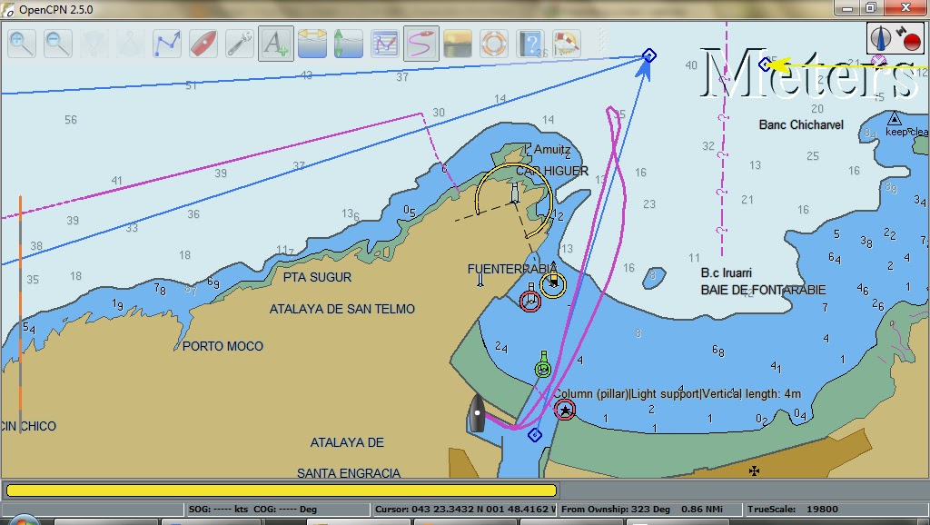
On looking further at the
charts we ran into the next conundrum - where to go next. Into the Gironde
Estuary was looked a nice days sail away...but if we left the Oleron channel on
the high tide at our hull speed it was the wrong state of tide to enter the
Gironde. OK, so the forecast was good, we were well rested, how about we carry
straight on to Arcachon....wrong state of tide again. Back to plan B, go round
the north of Oleron..but every option we looked at had the same problem, it was
always going to be the wrong time of tide, and/or impossible with the wind in
the north to get in anywhere.
Another study of the meteo
and we made the decision to head straight for Bayonne, which was enterable at
most states of tide. We needed to go back down the Charente river on the ebb
tide to opted for an overnight anchorage on Ile D’Aix, very close to Fort
Boyard. The short distance from the mouth of the Charente across to the island
was wind against tide and John had to work very hard using the twin engines to
steer us across. Once in the lee of the land we headed for the shallows and
took a drying mooring and settled down for the night.
It was an midday tide to
start the journey so we had a relaxing morning checking every meteo report to
ensure that we were making the best decision. All was looking good, the
northerlies were forecast for several days, it was clear blue sky and sunshine
and a calm sea state.
The passage started well,
as we neared the road bridge that connects the island to the mainland we both
stated having doubts as to its height. The chart didn’t have the height and
John did his usual trick of comparing the height of the lampposts on the bridge
to the gap below, and this confirmed there was plenty of height. As we
approached the angle became deceptive and with John out on deck and me at the
helm we crept underneath and breathed a sigh of relief as we passed through. On
later checking a different chart we had about 10m to spare, but it certainly
didn’t seem that way at the
time.
The channel was well buoyed
and only varied slightly from our charts. The final approach to the open sea
was unsettling for me as we had breaking waves on both sides (complete with
people surfing), but the buoyed channel through the deeper water had no surf
and we safely entered the Atlantic waters once more. Sail up, time to head
south, John bagged the first sleep and off we set. The next 24 hours passed
pleasantly and on the second afternoon, we sat out on deck drinking a cup of
tea and thinking this was the life.
Not long after the wind
dropped to virtually nothing, no problem, engine on, motor ahead. By this time
we were about half way down the sand dune that runs from Arcachon to Bayonne.
Out of nowhere, the wind turned and very quickly built up to a southerly force
7. The seas became very short and steep and very uncomfortable. The dinner that
I had enjoyed earlier soon fed the fishes and for an hour we battled on, hardly
making any progress over the ground. We made the call that we had to turn back
and so headed north, knowing that the next port was a long way off. It was
demoralising to say the least and I continued to feel very ill. We struggled on
through the night, making between 2 and 3 knots under bare poles (no sails, no
engines) for 17 miles.
At dawn, the wind veered to
the west and we decided to turn south again, and taking it in turns to sleep or
helm we battled through not just mine but John’s worst passage on record. My
spirits lifted a bit when the weather cleared enough to see the spectacular
mountain range of the Pyrenees with snow capped peaks. Around 6pm, after 56
hours and 200 miles we finally entered the river at Bayonne. Finding a suitable
anchorage proved impossible so we chose to find shelter in the marina, something
we wouldn’t normally do but under the circumstances felt was well deserved. The
capitainerie was closed but a few minutes after arriving the directeur appeared
and welcomed us to Bayonne, gave us access codes to the facilities and free
wifi and wished us a good night.
After 2 nights (11.5 euros
per night) of rest we headed out once more, this time for a short 12 mile hop
down to St Jean de Luz. After a slightly bumpy but expected exit from the river
at Bayonne we reached glassy seas, and I captured a contented John at the helm.
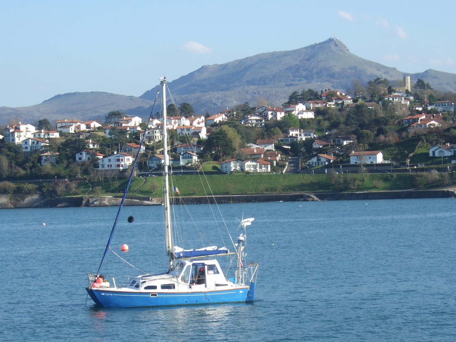
We had an enjoyable
afternoon sailing with views of more snow capped peaks behind Biarritz before
we entered the scenic bay of St Jean de Luz, 5 miles north of the Spanish
border. We anchored close to the fort at Socoa and took a gentle stroll around
the harbour.
I had been on holiday in the region about 8 years earlier and we
had climbed one of the local mountains, La Rhune, which is the back drop for
the bay.
After a peaceful night at
anchor, the weather didn’t last and a forecast westerly gale set in. We were
sheltered by the land and fort but decided it would be prudent to stay on board
in case of any problems. We spent the afternoon watching a video of “Singing in
the Rain” with very frequent interruptions from special meteo broadcasts
updating on the storm blowing through. By late afternoon the swell picked up,
despite the short fetch from the west, and in the evening we sought shelter in
the little marina at Ciboure-St Jean de Luz.
The Capitainerie was closed
but the adjoining bar was open, a fishing club rather than sailing, where we
were made very welcome and stayed for a drink. The barman declared the tab was
on him, we were welcome to return the following lunchtime so we thanked him and
headed back to the boat. After a morning stroll around Ciboure we returned to
the bar, were introduced to the president and spent an enjoyable couple of
hours discussing all things nautical. We were presented with a Basque courtesy
flag (something which we had tried but failed to buy beforehand) and in
exchange gave the club a St Piran flag. The tab was again on the house and we
returned to the boat for a siesta.
Later in the afternoon we
unfolded our bikes and cycled from one end of the bay to the other, it is a
truly beautiful bay and port and we felt something like normal once more and
the ground had stopped swaying.